Page updated at: 
If this page needs to be updated, please send me an email at mike@mikewalsted.com
Flight Planning Weather Graphics for Virginia
NWS WWs Convective Sigmets Icing Pireps Icing Airmets Freezing Level Turbulence Pireps Turbulence Airmets Obscuration Airmets Infrared Satellite Picture Visual Satellite Picture Unofficial Winds Aloft Radar Composite IMC/MVMC Areas Forecast IMC/MVMC Areas Surface Analysis Surface Forecast TFR

Severe Weather Advisories
NWS WWs Convective Sigmets Icing Pireps Icing Airmets Freezing Level Turbulence Pireps Turbulence Airmets Obscuration Airmets Infrared Satellite Picture Visual Satellite Picture Unofficial Winds Aloft Radar Composite IMC/MVMC Areas Forecast IMC/MVMC Areas Surface Analysis Surface Forecast TFR

Convective Sigmets and Airmets
NWS WWs Convective Sigmets Icing Pireps Icing Airmets Freezing Level Turbulence Pireps Turbulence Airmets Obscuration Airmets Infrared Satellite Picture Visual Satellite Picture Unofficial Winds Aloft Radar Composite IMC/MVMC Areas Forecast IMC/MVMC Areas Surface Analysis Surface Forecast TFR

Pilot Reports of Icing Conditions
NWS WWs Convective Sigmets Icing Pireps Icing Airmets Freezing Level Turbulence Pireps Turbulence Airmets Obscuration Airmets Infrared Satellite Picture Visual Satellite Picture Unofficial Winds Aloft Radar Composite IMC/MVMC Areas Forecast IMC/MVMC Areas Surface Analysis Surface Forecast TFR

Icing Airmets and Sigmets
NWS WWs Convective Sigmets Icing Pireps Icing Airmets Freezing Level Turbulence Pireps Turbulence Airmets Obscuration Airmets Infrared Satellite Picture Visual Satellite Picture Unofficial Winds Aloft Radar Composite IMC/MVMC Areas Forecast IMC/MVMC Areas Surface Analysis Surface Forecast TFR

Freezing Level Forecast
NWS WWs Convective Sigmets Icing Pireps Icing Airmets Freezing Level Turbulence Pireps Turbulence Airmets Obscuration Airmets Infrared Satellite Picture Visual Satellite Picture Unofficial Winds Aloft Radar Composite IMC/MVMC Areas Forecast IMC/MVMC Areas Surface Analysis Surface Forecast TFR

Pilot Reports of Turbulence
NWS WWs Convective Sigmets Icing Pireps Icing Airmets Freezing Level Turbulence Pireps Turbulence Airmets Obscuration Airmets Infrared Satellite Picture Visual Satellite Picture Unofficial Winds Aloft Radar Composite IMC/MVMC Areas Forecast IMC/MVMC Areas Surface Analysis Surface Forecast TFR

Turbulence Airmets and Sigmets
NWS WWs Convective Sigmets Icing Pireps Icing Airmets Freezing Level Turbulence Pireps Turbulence Airmets Obscuration Airmets Infrared Satellite Picture Visual Satellite Picture Unofficial Winds Aloft Radar Composite IMC/MVMC Areas Forecast IMC/MVMC Areas Surface Analysis Surface Forecast TFR

IMC/Obscuration Airmets
NWS WWs Convective Sigmets Icing Pireps Icing Airmets Freezing Level Turbulence Pireps Turbulence Airmets Obscuration Airmets Infrared Satellite Picture Visual Satellite Picture Unofficial Winds Aloft Radar Composite IMC/MVMC Areas Forecast IMC/MVMC Areas Surface Analysis Surface Forecast TFR

IR Satellite Picture
NWS WWs Convective Sigmets Icing Pireps Icing Airmets Freezing Level Turbulence Pireps Turbulence Airmets Obscuration Airmets Infrared Satellite Picture Visual Satellite Picture Unofficial Winds Aloft Radar Composite IMC/MVMC Areas Forecast IMC/MVMC Areas Surface Analysis Surface Forecast TFR

Visual Satellite Picture
NWS WWs Convective Sigmets Icing Pireps Icing Airmets Freezing Level Turbulence Pireps Turbulence Airmets Obscuration Airmets Infrared Satellite Picture Visual Satellite Picture Unofficial Winds Aloft Radar Composite IMC/MVMC Areas Forecast IMC/MVMC Areas Surface Analysis Surface Forecast TFR

2,500 Foot (MSL) Winds (Unofficial)

5,000 Foot (MSL) Winds (Unofficial)

10,000 Foot Winds (Unofficial)
NWS WWs Convective Sigmets Icing Pireps Icing Airmets Freezing Level Turbulence Pireps Turbulence Airmets Obscuration Airmets Infrared Satellite Picture Visual Satellite Picture Unofficial Winds Aloft Radar Composite IMC/MVMC Areas Forecast IMC/MVMC Areas Surface Analysis Surface Forecast TFR

Radar Composite from Unisys (unofficial)


Base Reflectivity from NWS (official)


Base Velocity from NWS (official)
NWS WWs Convective Sigmets Icing Pireps Icing Airmets Freezing Level Turbulence Pireps Turbulence Airmets Obscuration Airmets Infrared Satellite Picture Visual Satellite Picture Unofficial Winds Aloft Radar Composite IMC/MVMC Areas Forecast IMC/MVMC Areas Surface Analysis Surface Forecast TFR

Areas of MVMC and IMC
NWS WWs Convective Sigmets Icing Pireps Icing Airmets Freezing Level Turbulence Pireps Turbulence
Airmets Obscuration Airmets Infrared Satellite Picture Visual Satellite Picture Unofficial Winds Aloft Radar Composite IMC/MVMC Areas Forecast IMC/MVMC Areas Surface Analysis Surface Forecast TFR
Forecast areas of Flight Hazards (top) and precipitation (bottom)
NWS WWs Convective Sigmets Icing Pireps Icing Airmets Freezing Level Turbulence Pireps Turbulence Airmets Obscuration Airmets Infrared Satellite Picture Visual Satellite Picture Unofficial Winds Aloft Radar Composite IMC/MVMC Areas Forecast IMC/MVMC Areas Surface Analysis Surface Forecast TFR


Surface Analysis
NWS WWs Convective Sigmets Icing Pireps Icing Airmets Freezing Level Turbulence Pireps Turbulence Airmets Obscuration Airmets Infrared Satellite Picture Visual Satellite Picture Unofficial Winds Aloft Radar Composite IMC/MVMC Areas Forecast IMC/MVMC Areas Surface Analysis Surface Forecast TFR

Surface Forecast
NWS WWs Convective Sigmets Icing Pireps Icing Airmets Freezing Level Turbulence Pireps Turbulence Airmets Obscuration Airmets Infrared Satellite Picture Visual Satellite Picture Unofficial Winds Aloft Radar Composite IMC/MVMC Areas Forecast IMC/MVMC Areas Surface Analysis Surface Forecast TFR
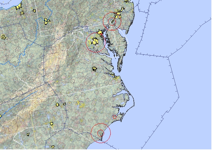
Temporary Flight Restrictions
NWS WWs Convective Sigmets Icing Pireps Icing Airmets Freezing Level Turbulence Pireps Turbulence Airmets Obscuration Airmets Infrared Satellite Picture Visual Satellite Picture Unofficial Winds Aloft Radar Composite IMC/MVMC Areas Forecast IMC/MVMC Areas Surface Analysis Surface Forecast TFR
Please send suggestions or comments to mike@mikewalsted.com.