Page updated at: 
If this page needs to be updated, please send me an email at mike@mikewalsted.com
NWS WWs Convective Sigmets Icing Sigmets Turbulence Airmets Obscuration Airmets Infrared Satellite Picture Visual Satellite Picture 10,000ft Winds FL180 Winds FL240 Winds FL300 Winds FL350 Winds FL390 Winds FL450 Winds FL530 Winds Radar Composite IMC/MVMC Areas Forecast IMC/MVMC Areas Surface Analysis Surface ForecastFlight Planning Weather Graphics

Severe Weather Advisories
NWS WWs Convective Sigmets Icing Sigmets Turbulence Airmets Obscuration Airmets Infrared Satellite Picture Visual Satellite Picture 10,000ft Winds FL180 Winds FL240 Winds FL300 Winds FL350 Winds FL390 Winds FL450 Winds FL530 Winds Radar Composite IMC/MVMC Areas Forecast IMC/MVMC Areas Surface Analysis Surface Forecast
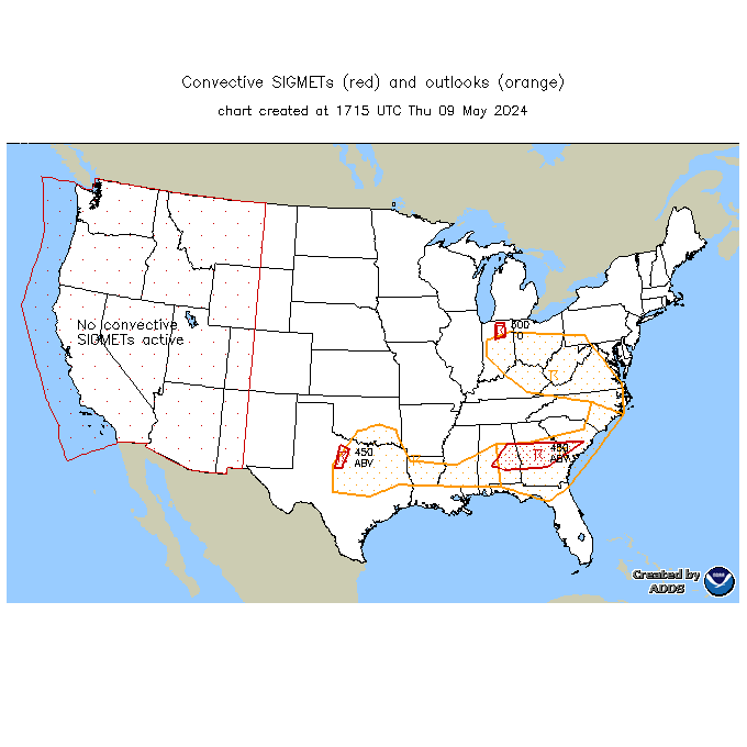
Convective Sigmets and Outlook
NWS WWs Convective Sigmets Icing Sigmets Turbulence Airmets Obscuration Airmets Infrared Satellite Picture Visual Satellite Picture 10,000ft Winds FL180 Winds FL240 Winds FL300 Winds FL350 Winds FL390 Winds FL450 Winds FL530 Winds Radar Composite IMC/MVMC Areas Forecast IMC/MVMC Areas Surface Analysis Surface Forecast

Icing Sigmets
NWS WWs Convective Sigmets Icing Sigmets Turbulence Airmets Obscuration Airmets Infrared Satellite Picture Visual Satellite Picture 10,000ft Winds FL180 Winds FL240 Winds FL300 Winds FL350 Winds FL390 Winds FL450 Winds FL530 Winds Radar Composite IMC/MVMC Areas Forecast IMC/MVMC Areas Surface Analysis Surface Forecast

Turbulence Airmets and Sigmets
NWS WWs Convective Sigmets Icing Sigmets Turbulence Airmets Obscuration Airmets Infrared Satellite Picture Visual Satellite Picture 10,000ft Winds FL180 Winds FL240 Winds FL300 Winds FL350 Winds FL390 Winds FL450 Winds FL530 Winds Radar Composite IMC/MVMC Areas Forecast IMC/MVMC Areas Surface Analysis Surface Forecast
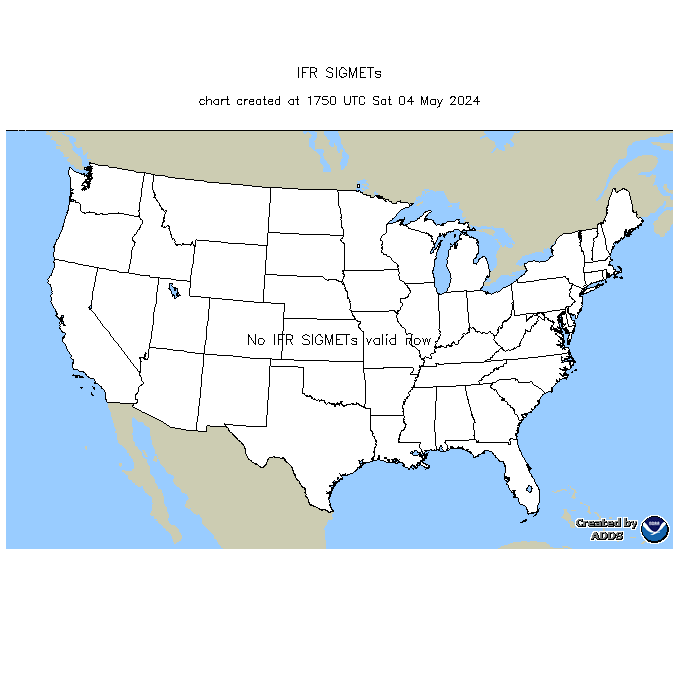
IMC Sigmets
NWS WWs Convective Sigmets Icing Sigmets Turbulence Airmets Obscuration Airmets Infrared Satellite Picture Visual Satellite Picture 10,000ft Winds FL180 Winds FL240 Winds FL300 Winds FL350 Winds FL390 Winds FL450 Winds FL530 Winds Radar Composite IMC/MVMC Areas Forecast IMC/MVMC Areas Surface Analysis Surface Forecast

IR Satellite Picture
NWS WWs Convective Sigmets Icing Sigmets Turbulence Airmets Obscuration Airmets Infrared Satellite Picture Visual Satellite Picture 10,000ft Winds FL180 Winds FL240 Winds FL300 Winds FL350 Winds FL390 Winds FL450 Winds FL530 Winds Radar Composite IMC/MVMC Areas Forecast IMC/MVMC Areas Surface Analysis Surface Forecast

Visual Satellite Picture
NWS WWs Convective Sigmets Icing Sigmets Turbulence Airmets Obscuration Airmets Infrared Satellite Picture Visual Satellite Picture 10,000ft Winds FL180 Winds FL240 Winds FL300 Winds FL350 Winds FL390 Winds FL450 Winds FL530 Winds Radar Composite IMC/MVMC Areas Forecast IMC/MVMC Areas Surface Analysis Surface Forecast
10,000 Foot Winds
NWS WWs Convective Sigmets Icing Sigmets Turbulence Airmets Obscuration Airmets Infrared Satellite Picture Visual Satellite Picture 10,000ft Winds FL180 Winds FL240 Winds FL300 Winds FL350 Winds FL390 Winds FL450 Winds FL530 Winds Radar Composite IMC/MVMC Areas Forecast IMC/MVMC Areas Surface Analysis Surface Forecast
FL180 (18,000 feet) Flight Level Winds
NWS WWs Convective Sigmets Icing Sigmets Turbulence Airmets Obscuration Airmets Infrared Satellite Picture Visual Satellite Picture 10,000ft Winds FL180 Winds FL240 Winds FL300 Winds FL350 Winds FL390 Winds FL450 Winds FL530 Winds Radar Composite IMC/MVMC Areas Forecast IMC/MVMC Areas Surface Analysis Surface Forecast

FL240 (24,000 feet) Flight Level Winds
NWS WWs Convective Sigmets Icing Sigmets Turbulence Airmets Obscuration Airmets Infrared Satellite Picture Visual Satellite Picture 10,000ft Winds FL180 Winds FL240 Winds FL300 Winds FL350 Winds FL390 Winds FL450 Winds FL530 Winds Radar Composite IMC/MVMC Areas Forecast IMC/MVMC Areas Surface Analysis Surface Forecast

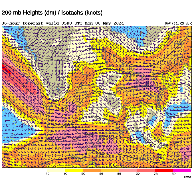
FL300 (30,000 feet) Flight Level Winds
NWS WWs Convective Sigmets Icing Sigmets Turbulence Airmets Obscuration Airmets Infrared Satellite Picture Visual Satellite Picture 10,000ft Winds FL180 Winds FL240 Winds FL300 Winds FL350 Winds FL390 Winds FL450 Winds FL530 Winds Radar Composite IMC/MVMC Areas Forecast IMC/MVMC Areas Surface Analysis Surface Forecast
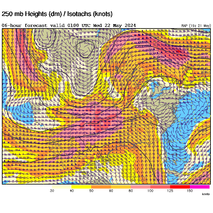
FL350 (35,000 feet) Flight Level Winds
NWS WWs Convective Sigmets Icing Sigmets Turbulence Airmets Obscuration Airmets Infrared Satellite Picture Visual Satellite Picture 10,000ft Winds FL180 Winds FL240 Winds FL300 Winds FL350 Winds FL390 Winds FL450 Winds FL530 Winds Radar Composite IMC/MVMC Areas Forecast IMC/MVMC Areas Surface Analysis Surface Forecast
FL390 (39,000 feet) Flight Level Winds
NWS WWs Convective Sigmets Icing Sigmets Turbulence Airmets Obscuration Airmets Infrared Satellite Picture Visual Satellite Picture 10,000ft Winds FL180 Winds FL240 Winds FL300 Winds FL350 Winds FL390 Winds FL450 Winds FL530 Winds Radar Composite IMC/MVMC Areas Forecast IMC/MVMC Areas Surface Analysis Surface Forecast

FL450 (45,000 feet) Flight Level Winds
NWS WWs Convective Sigmets Icing Sigmets Turbulence Airmets Obscuration Airmets Infrared Satellite Picture Visual Satellite Picture 10,000ft Winds FL180 Winds FL240 Winds FL300 Winds FL350 Winds FL390 Winds FL450 Winds FL530 Winds Radar Composite IMC/MVMC Areas Forecast IMC/MVMC Areas Surface Analysis Surface Forecast

FL530 (53,000 feet) Flight Level Winds
NWS WWs Convective Sigmets Icing Sigmets Turbulence Airmets Obscuration Airmets Infrared Satellite Picture Visual Satellite Picture 10,000ft Winds FL180 Winds FL240 Winds FL300 Winds FL350 Winds FL390 Winds FL450 Winds FL530 Winds Radar Composite IMC/MVMC Areas Forecast IMC/MVMC Areas Surface Analysis Surface Forecast


Radar Composite

Lightning data from Accuweather
NWS WWs Convective Sigmets Icing Sigmets Turbulence Airmets Obscuration Airmets Infrared Satellite Picture Visual Satellite Picture 10,000ft Winds FL180 Winds FL240 Winds FL300 Winds FL350 Winds FL390 Winds FL450 Winds FL530 Winds Radar Composite IMC/MVMC Areas Forecast IMC/MVMC Areas Surface Analysis Surface Forecast

Areas of MVMC and IMC
NWS WWs Convective Sigmets Icing Sigmets Turbulence
Airmets Obscuration Airmets Infrared Satellite Picture Visual Satellite Picture 10,000ft Winds FL180 Winds FL240 Winds FL300 Winds FL350 Winds FL390 Winds FL450 Winds FL530 Winds Radar Composite IMC/MVMC Areas Forecast IMC/MVMC Areas Surface Analysis Surface Forecast
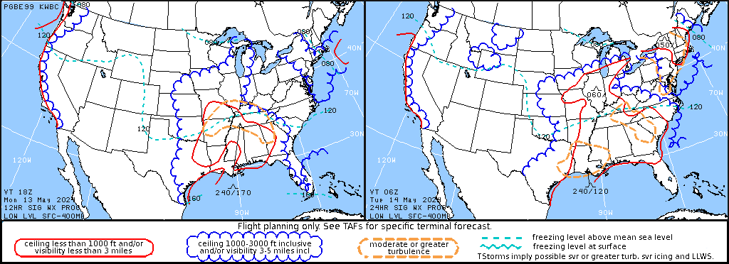
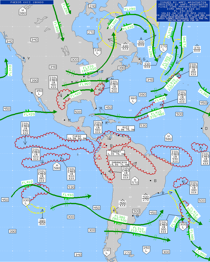
Forecast areas of Flight Hazards
NWS WWs Convective Sigmets Icing Sigmets Turbulence Airmets Obscuration Airmets Infrared Satellite Picture Visual Satellite Picture 10,000ft Winds FL180 Winds FL240 Winds FL300 Winds FL350 Winds FL390 Winds FL450 Winds FL530 Winds Radar Composite IMC/MVMC Areas Forecast IMC/MVMC Areas Surface Analysis Surface Forecast

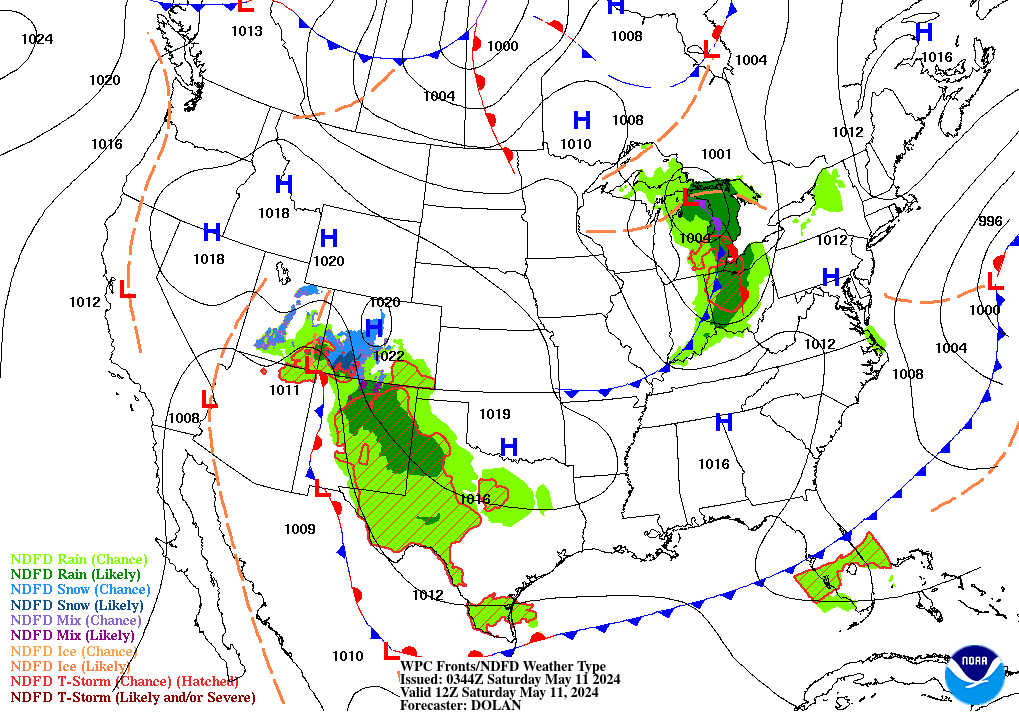
Surface Analysis
NWS WWs Convective Sigmets Icing Sigmets Turbulence Airmets Obscuration Airmets Infrared Satellite Picture Visual Satellite Picture 10,000ft Winds FL180 Winds FL240 Winds FL300 Winds FL350 Winds FL390 Winds FL450 Winds FL530 Winds Radar Composite IMC/MVMC Areas Forecast IMC/MVMC Areas Surface Analysis Surface Forecast
Surface Forecast
NWS WWs Convective Sigmets Icing Sigmets Turbulence Airmets Obscuration Airmets Infrared Satellite Picture Visual Satellite Picture 10,000ft Winds FL180 Winds FL240 Winds FL300 Winds FL350 Winds FL390 Winds FL450 Winds FL530 Winds Radar Composite IMC/MVMC Areas Forecast IMC/MVMC Areas Surface Analysis Surface Forecast
Please send suggestions or comments to mike@mikewalsted.com.